We at maps.wow.gl provide a community-service to share tracks. Find it here.
HOW TO IDENTIFY POSITIONS ON THE MAPS
The map uses two coordinate systems, latitude and longitude and the international standard, metric UTM system. Both are based on the WGS-84 model for the shape of the Earth. Any location on the map can be described using either coordinate system. The latitude / longitude system is aligned with true north and is commonly used by mariners and pilots. The UTM system is aligned with grid north, which deviates by less than one degree from true north on the maps, and is more commonly used by hikers. The advantage of the UTM system is that coordinates are expressed in metres and so it is very easy to work out the distances between locations, much more so than with the latitude / longitude system.
When using the map, it is strongly recommended to use the UTM system for locations because of its high accuracy. However, map users may wish to also use the latitude / longitude system, for example when communicating with the emergency services.
Latitude / Longitude system
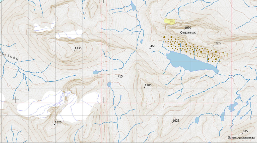
Latitudes and longitudes are shown on each map by a series of black crosses. In Greenland, latitudes increase in a northerly direction towards the top of the map, and longitudes increase in a westerly direction towards the left side of the map. Crosses appear at intervals of four minutes of longitude, and two minutes of latitude. There are sixty minutes within each degree. Minutes are usually expressed as decimal minutes. Examples of locations given in longitude and latitude for each map are as follows:
- Map 1 – Nuuk. The summit of Store Malene is located at a longitude of 51°38.5’W and a latitude of 64°09.9’N
- Map 2 – Qooqqut. The summit of Itisoq is located at a longitude of 51°12.1’W and a latitude of 64°16.2’N
- Map 3 – Ameralla. The summit of Aqajamernit Qulaat is located at a longitude of 50°37.1’W and a latitude of 64°17.4’N
- Map 4 – Akiata Kangia. The summit of Qaarusuup Qaqqaa is located at a longitude of 51°22.2’W and a latitude of 64°23.5’N
- Map 5 – Qoornoq. The summit of Kangersuaq is located at a longitude of 50°53.1’W and a latitude of 64°35.0’N
- Map 6 – Kapisillit. The summit of Kiinaasaq is located at a longitude of 50°30.9’W and a latitude of 64°27.2’N
UTM system
In the UTM system, the Earth is subdivided into zones in the north and south hemispheres. Most of west Greenland is represented by the UTM 22 North (or UTM22N) subdivision and all of the maps fall within this zone. A grid of dark grey, one kilometre-spaced lines following the UTM22N grid is shown on each map. Coordinates shown at the top and bottom of the map are eastings and, as the name suggests, increase to the east. Coordinates shown on the left and right side of the map are northings and, similarly, increase to the north. When giving a coordinate for a position in UTM, the easting is always quoted first and it is easy to tell the difference between eastings and northings in Greenland because northings always have seven digits and easting always have six. For simplicity, most of the numbers on the axes of the maps are abbreviated to whole kilometres by removing the last three zeros (representing metres) and the first digit in the case of eastings and the first two digits in the case of northings. The full UTM coordinates are shown on the axes at all four corners of the map. So, for example, ‘45’ appearing on the bottom edge of a map is an abbrevation of the easting 445000 and ‘22’ appearing on the left edge of a map is an abbreviation of the northing 7122000.
Examples of places on the maps, as expressed in the UTM system are as follows:
- Map 1 – Nuuk. The summit of Store Malene is located at (468 800, 7 115 400)
- Map 2 – Qooqqut. The summit of Itisoq is located at (490 200, 7 127 150)
- Map 3 – Ameralla. The summit of Aqajamernit Qulaat is located at (518 500, 7 129 400)
- Map 4 – Akiata Kangia. The summit of Qaarusuup Qaqqaa is located at (482 150, 7 140 700)
- Map 5 – Qoornoq. The summit of Kangersuaq is located at (505 500, 7 162 000)
- Map 6 – Kapisillit. The summit of Kiinaasaq is located at (523 350, 7 147 700)
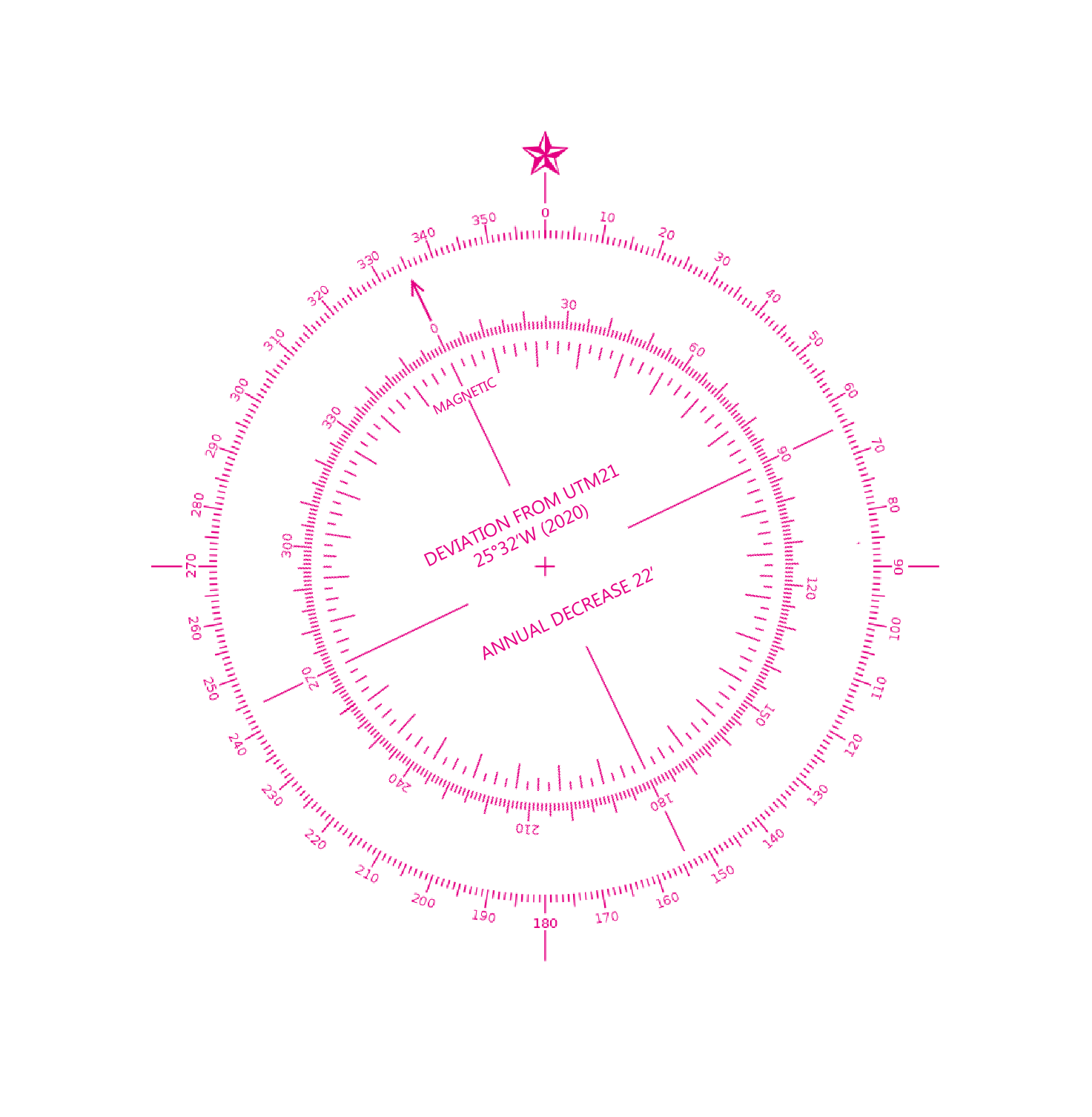
HOW TO IDENTIFY DIRECTIONS
Orientations along the UTM grid
The maps are oriented so that all lines parallel to the left and right sides of the map are directly aligned with north-south on the UTM22N grid system. The deviation between grid north and true north (the orientations used for latitude and longitude) vary from place to place on each map but are always less than one degree. The deviation between grid and true north is therefore small enough not to be important for hikers. Average deviations between grid and true north for each map are as follows.
- Map 1 – Nuuk. Grid north is 0.47 degrees west of true north
- Map 2 – Qooqqut. Grid north is 0.06 degrees east of true north
- Map 3 – Ameralla. Grid north is 0.56 degrees east of true north
- Map 4 – Akiata Kangia. Grid north is 0.44 degrees west of true north
- Map 5 – Qoornoq. Grid north is 0.02 degrees east of true north
- Map 6 – Kapisillit. Grid north is 0.55 degrees east of true north
The grid lines allow directions from one place to another to be readily described in the form north, east south-east, south-west etc. However, to be precise, users of the maps can use the compass rose shown on each map to describe directions accurate to one degree.
Orientations relative to magnetic north
The compass roses also show the average direction to magnetic north for each map. The deviation between magnetic and grid north (“declination”) varies from place to place on each map and changes over time. However, since the variation is less than one magnetic degree within the boundaries of each map, for the purposes of hiking it is reasonable to use the one compass rose to identify directions relative to magnetic north anywhere on each map. The difference between grid and magnetic north is very significant in the Nuuk area. In 2020, magnetic north is oriented approximately 26 degrees west of grid north. What this means is that if a direction is quoted as ‘magnetic’ a value of 26 must be subtracted from that direction in order to locate it using the degree subdivisions shown on the compass roses. For example, a direction of 270° magnetic would follow 244° grid on the map. Average magnetic deviations for each map are as follows:
- Map 1 – Nuuk. Magnetic north is 25.53 degrees west of grid north
- Map 2 – Qooqqut. Magnetic north is 25.9 degrees west of grid north
- Map 3 – Ameralla. Magnetic north is 26.35 degrees west of grid north
- Map 4 – Akiata Kangia. Magnetic north is 25.78 degrees west of grid north
- Map 5 – Qoornoq. Magnetic north is 26.1 degrees west of grid north
- Map 6 – Kapisillit. Magnetic north is 26.46 degrees west of true north
A convenient way of navigating using the map is to use a handheld compass and physicaly set the declination on the compass to a value suitable for the map. Bearings measured on the compass can be directly transferred to the map, automatically corrected for the difference between magnetic and grid north.
The location of the magnetic north pole changes over time and in the early part of the 21st century has been moving relatively quickly. Over the areas covered by the maps, in 2020, the magnetic north pole has been moving east, closer toward grid north, by approximately 22 minutes (0.37 degrees) each year. What this means is that correcting between orientations in grid or magnetic systems must take account of the year that the map is being used. To correctly set-up compasses to show grid orientations, users are directed to the internet to establish the correct current declination at a particlar place and time. GPS units will usually display the current deviation between magnetic and true north at any location on the Earth and this information can be used to calibrate compasses.
When quoting directions, it is important to always follow the direction name (e.g. ‘west’) or number (e.g. ‘270’) by the words ‘grid’ or ‘magnetic’ to discriminate between the two, strongly divergent systems of orientation. Similarly, while the default is usually a grid orientation, users of GPS units and smartphones should be careful to make sure that it is clear whether directions are quoted as grid or magnetic.
As indicated on the maps, users should be aware that some rocks can be strongly magnetic and such rocks are quite common, particularly in the eastern part of Nuup Kangerlua. The effect of rocks on a compass will change depending on how close the compass is to a magnetic rock. If the compass is seen to change direction as it is placed near to the ground it demonstrates that rocks in the area are magnetic and care should be used when assuming that the compass is correctly reading the direction to magnetic north.