A key to the features shown is presented on each map. However, the following provides a fuller explanation of the sources and meanings of the various annotations.
NATURAL FEATURES
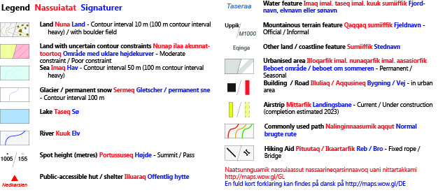
Areas of land are discriminated from sea by a light brown shading and the presence of brown contours showing lines of equal height above sea level. Contours are provided in 10-metre intervals. Rivers and lakes are shaded in mid-blue. The sea is shaded in a light blue and with contours displayed at intervals of 50 metres water depth.
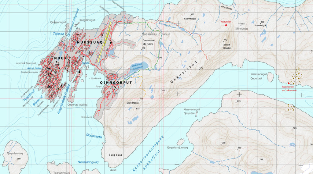
There is one cave identified, Qangattannguaq, which appears on the Ameralla map sheet.
Sea Contours

Water contours derive from the 2020 Version 4.0 of the International Bathymetric Chart of the Arctic Ocean (IBCAO) 200-metre grid and should not be used for marine navigation nor any other purpose involving safety at sea. Among the sea contours at intervals of 50 metres water depth, every hundredth metre contour is shown in a heavier weight.
Land Contours

Land contours are shown at 10-metre intervals and with every hundredth metre contour shown in a heavier weight to allow quick identification of terrain height. Contour lines were generated by processing DigitalGlobe Inc. 2-metre resolution 2019 satellite data derived from the WorldView cluster of satellites. Tiles were stitched and levelled by Asiaq Greenland Survey. A small number of areas had holes in the data, due to atmospheric effects or shadows generated by very steep terrain, or else generated computational artifacts giving rise to unrealistic terrain. Corrections were made to modelled contours in these areas by using data from other strips of satellite data, satellite images and previously published maps. In fourteen cases throughout the whole series of six maps, uncertainty of the hand-drawn contours was considered to be high. These areas are clearly identified on the maps with red stripes. In total they comprise only 2 km2 over the whole 5670 km2 covered by the Map Series. Users of the maps should take extra care in these small areas. In addition to the areas of poor contour constraint, the maps show twenty-seven areas of moderate constraint over 7.6 km2, shown on the maps with a yellow shading. These are areas where some corrections have been made and are considered to be reliable but do not have the same extremely high accuracy as other parts of the maps.
Spot heights

Spot heights for prominent peaks or mountain passes are included on all maps. Where previously-published heights on official maps coincide with the heights derived from satellite data, the original surveyed heights are retained. However, some older-surveyed heights have been found to be inconsistent with the more precise, modern satellite data, sometimes of the order of 100 metres. In such cases, older data have been omitted and instead new spot heights, accurate to 5 metres, have been included on the maps. Aappalaartoq, on Qeqertarsuaq (Qoornoq Map) has been found to be 190 metres lower than previously published and an unnamed 1126-metre peak immediately to the north-east has lost 140 metres over prior measurements. A 1325-metre peak north-east of Tuapassuit (Qooqqut Map) has lost 155 metres over prior publications whereas the 1305-metre peak on the ridge east of Qooqqut and upstream of Kuuersariaq has gained 115 metres over earlier surveys. All other spot-heights differ from prior publication by less than 100 metres.
Place names


All official placenames were provided by the Greenlandic naming authority, Oqaasileriffik. These appear at the locations mandated by Oqaasileriffik with the exception of a few changes to avoid overlapping names or other annotations. All Greenlandic placenames folllow the modern Greenlandic spelling conventions. Where Danish names are commonly used for some places these are shown immediately adjacent to their Greenlandic equivalents. Mountain peaks and other mountainous features such as cliffs, gorges and scree fields are identified with black-coloured text. A small number of commonly-used unofficial names appear on some of the maps in black italics. Historical sites are labelled with their reported official names, as archived by Oqaasileriffik, also in black. Such sites may be building ruins or foundations, grave sites, cooking places, tent sites, middens or hunting sites, and may have been used by Inuit peoples or Viking settlers. Other land features such as peninsulas, coastlines, islands and expanses of land are labelled in grey.
INFRASTRUCTURE


Aside form the nine Sermerssoq Kommune public huts, the only built infrastructure included on the maps appears within the confines of the city of Nuuk and the settlement of Kapisillit. These buildings, roads and marine constricutions derive from Asiaq Greenland Surveys Grundkort (dato January 2020). The extents of the abandoned settlement of Qoornoq and the summer settlement of Qooqqut are shown by dashed grey shading on their respective maps.
Huts

Both Ameralik and Nuup Kangerlua host hundreds of houses, huts and other structures. Some are abandoned while others are used by private individuals or may be shared communaly. The locations of these structures change over time as new structures are built or fall into disrepair. Hence private buildings are only shown within the boundaries of the current settlements of Nuuk and Kapisillit. The exceptions are the nine public huts which were built by Sermersooq Kommune and are freely available for use by members of the public without prior arrangement. These are shown on maps 1-Nuuk, 2-Qooqqut, 3-Ameralla and 6-Kapisillit and extend over the commonly used hiking route between Nuuk and Kapisillit. These huts are named and identified on the maps with red triangles.
Airstrips

The only airstrips in the Nuup Kangerlua Series of maps appear on Map 1-Nuuk. These are, at the time of publication (2020), the current airstrip at Nuuk airport (BGGH) and the immediately adjacent runway under construction which is scheduled to enter service in 2023. These are accuratley placed, however, they should not be used for air navigation, nor should any other features of the Map Series.
Routes and hiking aids


The premise of the Nuup Kangerlua Map Series is to allow users to navigate and explore safely on their own. However, it is recognised that particularly for short-term visitors it is useful to follow established trails. As a consequence, the three commonly-used hiking routes in the immediate vicinity of Nuuk are shown on Map-1 Nuuk. These trails are not paths but are used commonly enough to make the passage of previous visitors quite evident and in addition, coloured rocks appear along all three trails to aid hikers. Furthermore, Map-1 Nuuk shows the locations of a small bridge (renovated in 2019) and fixed rope through the boulder field at the north side of Kangerluarsunnguaq (Kobbefjord).